Sunday, September 21, 2014
I'm Going Hunting
Heck with it. I can't resist saying goodbye to the bears on the last day of the season. To the wilderness . . .
Did Not Go Hunting
And now I have that sick feeling in my stomach when I miss a prime hunting opportunity . . . The life of a hunter. Bear season over.
Saturday, September 20, 2014
To Bear Hunt Or Not To Bear Hunt
It's 1:30 in the morning. Today is the last day of the bear season. I'm up late working on some writing that desperately needs worked on and probably should be worked on for the entirety of the day. I should be responsible and stay home and write, and I'm tired of entering the woods, well, tired. This is a no win. I will rue the day regardless.
Tuesday, September 16, 2014
Hunt Report - 9-14-2014
Scout. Hunt. Scout. Hunt. Scout. Scout. Scout. Scout. Scout. Season over.
Well, at least that's how it feels. My hunting trips are really just glorified scouting trips, only I carry a shotgun, game bags, and an ever-diminishing sliver of hope. I suppose the scouting is necessary due to my limited knowledge of the area, but the endless walking and the noise that comes with it obliterates any reasonable chance of taking a bear.
This is one of my great weaknesses when it comes to hunting: I love to explore (cough: scout), and I justify this obsession by convincing myself that the area just over the next ridge could be bear mecca. Of course, that's hardly ever the case. More likely, as I am quickly discovering, it's just a bramble of maples and birches with little to no bear sign.
Sunday was no different. My plan was to hike four miles in to a prominent saddle, spend the morning overlooking the saddle, and then slowly work my way back to the truck doing calling sets every half mile or so. I had never been to the saddle before but was convinced that it must surely funnel wildlife between the two drainages. Arriving a bit late to the trailhead, daylight found me an hour into the hike, with still another hour and a half left to hike before reaching the saddle. When I did finally arrive, I was sorely disappointed: there was nothing of great significance. I probably should have been more vigilant in trying to locate sign, but the area simply did not have that magical feel and I figured my time would be better spent elsewhere.
After a brief snack, I headed back down to the (Beaverkill) River. That took about another hour or so, during which I second-guessed my decision to hike to the saddle in the first place instead of simply hunting one of the areas where I had previously found some sign of bear. It was roughly 11 o'clock when I arrived at the river. Feeling slightly defeated and overly exhausted, I decided to take a nap, which I managed to successfully do for the better part of an hour. This would remain one of the few successes of the day.
Once I woke, I decided to follow the river until it concluded just at the edge of some private property. However, I got confused when I crossed a stream that I thought was indicated on the map, making me believe I had hiked much further than I had actually done. So I turned back and by the time I had discovered my mistake I had gone too far to backtrack. That area is still on my scouting list.
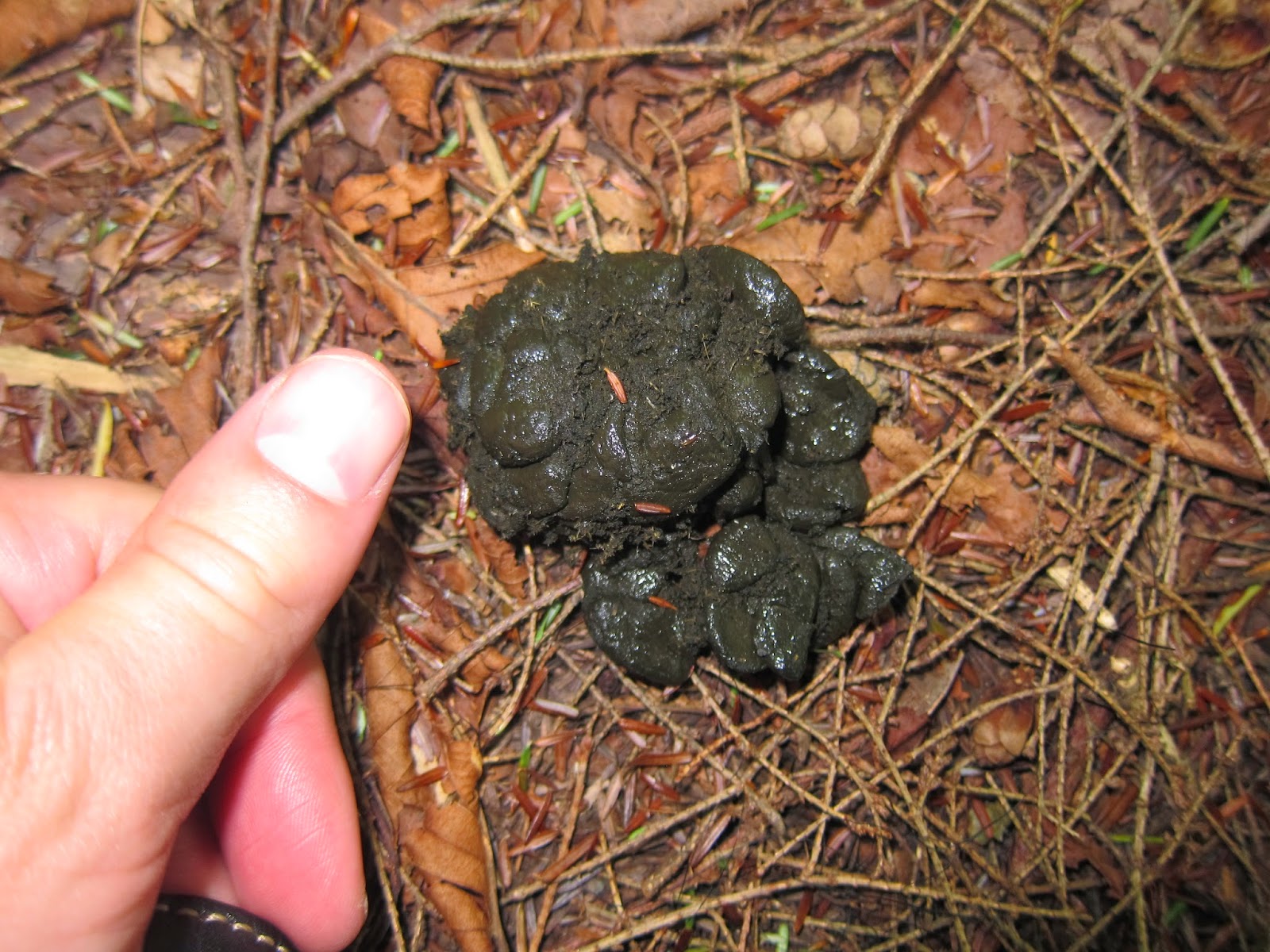
At that point, I decided to call it a day and go spend some time with the family rather than aimlessly wandering around the woods. In other words, I was defeated. I still had yet pull the trail camera though, and so I made my way in that direction. I arrived at the camera about 2:30 and sat down to have lunch before heading to the truck. While eating I realized I could view the trail camera pics by placing the memory card in my regular camera. Much to my surprise, there I found one photo of a mother bear and her cub, apparently grazing the berries that lay in front of the camera.
The sight of bears at the very location I was standing gave me a great boost in confidence and made me think I should do a calling set close by in hopes of pulling in a bear, though not the ones in the photo since it is illegal to take any bear that is with another bear.
After getting setup, I called for about 30 minutes. Nothing showed. This was of no surprise. My calling is quite terrible, and at one point I actually felt guilty for subjecting every animal in a half-mile radius to my pitiful and obviously manufactured rabbit distress call. After waiting another 30 minutes for nothing to appear, I headed for the truck and arrived there at 6:30. That was my day. Lots of walking, and very little hunting. I suppose I can't expect much when that is the case. This is doubly true due to missing the morning and evening hunting periods, easily the best time to be situated in a stand and actively hunting.

The camera was in place for eight day. This is the only picture that captured wildlife. This is a mild success. Four weeks ago I had yet to step foot in any of the Catskill Parks. That I can locate bear, an animal I have never hunted before, in a somewhat vast park is definitely an accomplishment. However,the cynical side of me won't let myself celebrate for too long. Had I hunted everyday that week in this exact location I would have only seen two bears, neither of which I could have killed. That's not the best of odds so to speak.
And now on to more photos.

The open marsh just left of where the bears were photographed.

Tough to see in the photo, but the vegetation is beaten down.

I'm trying to be more observant with sign. Here I think the ends of some berry bushes have been broken off.

Not the best print for identification purposes. When I first found it, I was 50/50 on whether it was a bear, though not sure what else would have an imprint like that. Then I pulled the trail camera that was forty yards away and found the photo with the bears.
Saturday, September 13, 2014
Gear Improvements
Added a scope to the shotgun. It's a cheap little scope that I got used for 45 bucks, but it's is an improvement from the very, very basic open sights I was using. The scope, rings, and labor came to a total of $85. It was either have the shotgun scoped or buy a rifle, and I just don't have $1,000 to burn right now, so it's another year of lugging the shotgun around. At least now I have a little more confidence in the gun and its improved accuracy. As a side note, the gunsmith bore-sighted it for me when he installed the scope. First shot was dead on. Slugs run about $17 for a box of five, and without the bore sight it probably would have taken me at least seven shots. In other words, he saved me about $25.


I also made some adjustments to my pack. The pins on it were a bit noisy so I secured them with flagging tape. I also removed the two straps of webbing that helped cushion the pack against my back, which they never really did considering they were just a thin piece of nylon.
Up in four hours. We'll see what the day holds . . .
Thursday, September 11, 2014
Plant ID - Hobblebush (Viburnum alnifolium)

When I first saw this plant while scouting around Tunis Pond two weeks ago, I got pretty excited. At that time, the berries had yet to open and all that was visible was the large seedpods, which I surmised held bundles of wild hazelnuts (Corylus cornuta). Since wild hazelnuts are a staple food for bear, I reasoned that the area would soon be swarming with bears once the hazelnuts appeared. Two weeks later, I return and found that some of these hazelnut trees were actually bearing (not intended) fruit, not nuts as expected. Still not wanting to except the reality of the situation, I further reasoned that the plants that held berries likely did so because the plant was a specific gender, say, female and that the males must be the ones that produce the bear-inducing nuts.
My confidence in that analysis finally eroded today (for no particular reason beyond time and the general reasoning capabilities that comes with it) and so I went to google and searched "native plants Catskills." Lo & behold there is actually an organization dedicated to protecting and enhancing the public's knowledge of native plants in the Catskills. It's called the Catskill Native Plant Society and they have a facebook page. It is there that I found a picture of my wild hazelnut tree. As expected, it's not a wild hazelnut; it's a hobblebush, Viburnum alnifolium (or lantanoides). Some more info can be found here. Some reports mention that bears will eat the fruit, but I doubt it's a bear magnet like wild hazelnuts. We will see.
Here is what the wild hazelnut looks like:
 |
| http://hudsonvalleygeologist.blogspot.com/2010/07/witch-hazel.html |
Here's more pics of the hobblebush:


I should mention that their fruits will actually turn black when they are fully ripe. I tried a couple of the berries. They are a little sweet but mostly bland and unmemorable.
Tuesday, September 9, 2014
Cutting Weight from the Hunting Pack
So the pack nearly killed me the other day. I'm not sure what it weighed, but it was probably somewhere close the 30 pound mark. By the end of the day, it felt like 100lbs. Maybe I didn't get enough sleep and was just sore. Or maybe I should have dropped most of the weight at a base camp and then went about hunting from there. Or maybe I'm just getting old. Whatever the reason, it convinced me that I need to cut some weight off the pack. Otherwise, it will eventually cut down on my mobility, and in terms of bear hunting that's about the only thing I have going for me.
Here's the revised list, with commentary:
GEAR
Here's the revised list, with commentary:
GEAR
- Matches
- 3-4 small pieces of pitchwood (I'll demonstrate later)
Esbid StoveIt doesn't weigh much, but I'm desperate.- 3-4 esbid fire pellets
2 cup cooking potWill have to take along if I'm staying overnight.- Water pills (in case it comes to that)
- 50' of small diameter parachute cord 25' should suffice.
- Map It's a regional map of the entire Catskills, and it's laminated. So as far as maps go, it's heavy. But is it worth cutting up your map to save a few ounces.
- Compass
- GPS
- Aspirin/Pain Killers
Felco Saw (to procure wood. Trust me, can't beat it)Due to the limited understory and therefore lack of firewood, it was necessary to carry this where I hunted in Washington so that I could cut larger pieces of wood. This is not the case in the Catskills. I can find enough 1" thick sticks where I hunt to make a 100 campfires.- Headlamp
Flagging tape (to mark blood trail and my own trail if I get lost)I'll find another weigh to mark the trail.
HUNTING EQUIPMENT
- 12 gauge (easily the heaviest item in the pack) This thing is an anvil, but nothing I can do about it.
- 6 sabot slugs
- Pocket Knife
- Fillet Knife (The most useful and multi-purpose knife I have ever owned)
Trail Camera- 5 Game Bags
- Bag of Pepper (to keep the flies off the meat while quartering it) Only weighs a couple ounces, but the smell is impossible to contain. I have it wrapped in two heavy freezer bags and the smell still permeates.
- Predator calls
- Hunting License
FOOD:
Sweet & sour pork freeze dried mealOnly if staying overnight.Omelet freeze dried meal Ditto4 packages of instant oatmealDitto- Chunk of trail sausage
2 peachesDried fruit.- 1 powerbar
- About a pound of trail mix
- Lots of water 1 large nalgene, and one small nalgene.
Powerbar
CLOTHING
- Cotton camo pants The cotton ones are heavy, might go with my synthetics.
2 pairs of wool socksOnly if staying overnight.2 pairs of silk liner socksDitto- Camo rain/all-purpose jacket
- Blaze orange vest Will be wearing my lighter one.
- Fleece
Wool flannel (I take it everywhere, no matter what the temperature)Love it but don't need it in this weather.- Hiking boots
- Camo facemask
1 stocking capDitto- 1 baseball cap
- 1 boonie hat
2 wool/silk liner shirtsNever wore a one of them- 1 tee shirt
Well, after revising the list, I'm a bit disappointed that I couldn't cross off more items. I suppose I'm already a bit thin on the gear and all. It would be interesting to weigh my pack, as well as the items I deleted to see just how much weight I cut. I'm guessing it's the weight of that shotgun that ultimately got the best of me. That thing is not built for backcountry hunting.
Sunday, September 7, 2014
Hunt Report - Bear Opener
To the wilderness . . .

Unsurprisingly, I woke up a bit late Saturday morning and didn't make it to the trailhead until an hour after first light. Nothing is more defeating to me than arriving late to a hunt, particularly a morning hunt for bear when the best time to be in the woods in the first two hours or so. The hike from the trailhead to Tunis pond takes me about 1 hour and 15 minutes to complete and I figured it would take another 30 minutes to setup once I got there. So in all, I was 2 hours and 45 minutes late. Not the best start to the bear season. To make matters worse, I was feeling the aches and pains that come with only getting four hours sleep. Feeling a bit defeated, I decided to make it a day hunt and quickly went through my pack for things to leave at the truck. At the mile mark, I could tell my pack was way too heavy, particularly for a day hunt. The smart thing to do would have been to stash some of my items along the trail, but somehow that thought never entered my mind.
By the time I got to Tunis Pond, I was ready to shed the pack. Having barely scouted Tunis on the last trip, I took the blown hunting opportunity to thoroughly scout the area. Shedding the pack, I began to scout around. I was hoping to find that smoking gun of fresh sign--steaming piles of scat, a well worn trail, a rubbing tree, etc--that would tell me inconclusively where to place my stand and give me great confidence going forward. There would be none of that. Aside from a few piles of old scat, I found next to nothing. There are some trails, but I'm unsure if they are being used by bear. I did set a trail camera on one of these trails, but it was mostly because I was tired of hauling the weight around and I don't expect to see much come next week when I pull the camera.
With little if any sign, I decided to head further down the trail and follow the Beaverkill river once it splits from the trail. The hike from Tunis to the Big Indian Wilderness boundary (where the trail and river split) is spectacularly beautiful. I didn't find much sign along the Beaverkill, but I didn't go very far either. The habitat is intriguing. It feels bearish. As a last resort, I did one calling set, mimicking the sound of a distressed rabbit for the better part of forty minutes. I haven't practiced this type of calling before, and my inexperience was very noticeable, at least to the human ear. At one point, two bluejays joined in the chorus, which left me wondering why two bluejays were so interested in my call, and then I realized that the cadence of my calling sequence and the pitch of the call sound disturbingly close to the sound of an alarmed blue jay. Needless to say, I wasn't swarmed by bears.
A few faint tracks in the sand did catch my attention. At the time, I thought they were bobcat tracks, but after reviewing it further I believe it is indeed a bear track. If so, there are bear in the general area (this is the second set of track in the area), just not a lot of them and for any length of time. If I was hunting every day, I might be tempted to sit over a trail in hopes of catching one of these bears as the travel through the area, but I'm only hunting one or two days a week and I'm guessing the bears make a pass through the area about once a week. It's obvious to me then that the chances of me and the bear being at the exact same spot at the same time are quite slim. So I have hatched a new strategy, which is basically cover a much ground as possible, doing calling sets every half mile or so. So I have a week to improve my calling. We'll see.

The track that I think is a bear along the Beaverkill River.

Another view of the track that I think is a bear track.

Marshy area along the Beaverkill River where I made my calling set.

Just inside the marshy area where I made my calling set.

What's a blog post without pics of scat? I read that when you come across scat from a big bear that it is unmistakable. I think this qualifies.
Friday, September 5, 2014
Camping Supplies List
 So the bear opener is in about 6 hours away, and I've just finished packing. For the record, I started packing yesterday, but we recently moved and everything now seems to be in hiding from me. Here's my list, which can be seen above as well:
GEAR
- Matches
- 3-4 small pieces of pitchwood (I'll demonstrate later)
- Esbid Stove
- 3-4 esbid fire pellets
- 2 cup cooking pot
- Water pills (in case it comes to that)
- 50' of small diameter parachute cord
- Map
- Compass
- GPS
- Aspirin/Pain Killers
- Felco Saw (to procure wood. Trust me, can't beat it)
- Headlamp
- Flagging tape (to mark the blood trail and my own trail if I get lost)
HUNTING EQUIPMENT
- 12 gauge (easily the heaviest item in the pack)
- 6 sabot slugs
- Pocket Knife
- Fillet Knife (The most useful and multi-purpose knife I have ever owned)
- Trail Camera
- 5 Game Bags
- Bag of Pepper (to keep the flies off the meat while quartering it)
- Predator calls
- Hunting License
FOOD:
- Sweet & sour pork freeze dried meal
- Omelet freeze dried meal
- 4 packages of instant oatmeal
- Chunk of trail sausage
- 2 peaches
- 1 powerbar
- About a pound of trail mix
- Lots of water
CLOTHING
- Cotton camo pants
- 2 pairs of wool socks
- 2 pairs of silk liner socks
- Camo rain/all-purpose jacket
- Blaze orange vest
- Fleece
- Wool flannel (I take it everywhere, no matter what the temperature)
- Hiking boots
- Camo facemask
- 1 stocking cap
- 1 baseball cap
- 1 boonie hat
- 2 wool/silk liner shirts
- 1 tee shirt
MISSING ITEMS
- Tent (not a big fan of them unless it's cold)
- Sleeping bag (too warm for a bag)
- Scalpel & blades (welp)
- Spandex knee crops (welp. I wear them almost everywhere)
- Dried fruit (tough find)
- Bagels (easy find. I just forgot)
- Belt (welp. must find)
- First aid kit (must get one)
I'm only staying over one night, but I'm still a bit amazed how much weight is on the pack. No big deal for hiking, but I don't want to hunt with it all day. That means I must either make a base camp and leave all my stuff there or leave it all at the truck and just hike back at dark, perhaps even head home. At this point, I leaning towards the latter.

The pack fully loaded. I bought that pack for 5 bucks at the thrift store. Best backpack I have ever owned. And I have owned some rather expensive packs.

My freezer. I made a bunch of ice to leave in some coolers in the back of my truck. You know, in case I'm a lucky guy. Also, note the freezer is empty otherwise. I hate an empty freezer.
Wednesday, September 3, 2014
Scouting Report - Balsam Lake Mountain Wild Forest
As promised, here goes nothing . . . .


 At least a couple months old. Interestingly, I think those are acorn shells. Yet I didn't see any oak trees in the area. If those are acorns, then I'm guessing the scat is from the fall. It was solid.


Headed up to the Balsam Lake Mountain Wild Forest the other day to scout for bear.
This was my third trip to the area. My first trip, which I partly document here, was less than productive, though we did find some bear sign . For this trip, I relocated about three miles northeast to Balsam Lake Mountain Wild Forest trailhead at the end of Beaverkill Road (google maps shows it turning into Turnwood Road). I had found a couple small lakes on the map about two miles from the trailhead just off the Finger Lakes Trail. These turned out to be Vly Pond and Tunis Pond. I'm just a rookie when it comes to bear hunting, but my understanding is that bears love water and the often rich food sources its fringes hold. In this case, the open area in the forest canopy has to be good for forage. At the very least, I figured it was worth a shot. That's really all a person can do: identify areas from a map that look intriguing and then groundtruth those suspicions by putting boot to trail.
As I mentioned before, two miles probably eliminates just about 95% of hunters. So if Tunis held bear, I figured it was the perfect scenario: some type of habitat attraction or wildlife corridor that is just outside most hunters' range but well within my own. That it is easily accessed via hiking trails is a bonus. I didn't time my hike but I would guess it took me less than an hour to hike from Tunis to the trailhead (i was scouting on the way in). It's not the most physically exerting trail, but it does have its elevation gains that do get the heart rate moving at a decent clip (this is doesn't require much; I'm not in great shape these days). The forest is typical for the area: maples, birches, and hemlocks with a few beech trees in the mix as well.
Just before Vly Pond the trail crosses a dirt road. This was a surprise to me and my first reaction was utter despair. There were recent tire tracks on the road, and I figured someone had grandfathered rights to the road. Worst case scenario being that that someone is a hunting club. I still don't know, but my fingers are crossed. About a 1/2 mile after Vly Pond the trail intersects another road that the trail terminates into. The signs at the intersection give distances to the nearest locations, but do not provide directional arrows. I was unsure if I needed to turn left or right to stay on the trail. I had read that ownership rights along the Beaverkill River can be a bit confounding, and I didn't want to trespass on private property and have to deal with that headache. Luckily, I had preprogrammed coordinates into my GPS for Tunis Pond before heading out. A quick check of the GPS revealed that left led to Tunis. Still, the trail is essentially an old road, and I couldn't shake the feeling that I was on private property and should have instead made a right.
Tunis is another .25 mile or so after the turn (left). It's a beauty of a lake, and I found a fair amount of bear sign in the area, including a very fresh track. Most of the sign was on the backside of the lake along a well established trail, though I believe the trail is more the domain of deer than bear. The boggy area surrounding the lake holds some kind of small blackberries (blush, I don't know the name and I didn't take a picture). The hillside surrounding the lake is choked full of hazelnuts, with a few beech trees in the mix. In other words, it's got food aplenty. I got that tingly feeling I often get when I have found a prime location. At one point in my life, I would suppress that feeling and write it off as wishy-washy humdrum. Then I would unexpectedly spook an animal from the area and kick myself for not paying more attention to my gut feeling. I no longer ignore that gut feeling, and so, I will be hunting around Tunis Pond this Saturday for the opening day of bear season. I don't expect to get anything or, for that matter, even see anything. However, as the adage goes: you don't get anything sitting on the couch.
Being a rookie and all, I don't put much confidence into my bear sign interpretation skills. Below are some pics of sign I found. They are organized by how confident I feel in them being bear sign.
Sign I feel sure about:
Yep. Bear track.
Ditto
Ditto
Less sure about:
Doesn't get any fresher, but is it bear scat? The picture is deceiving. The scat is actually much larger, it just sank into the bog upon impact.
Fresh, small, and globbish. Deer or Bear?
Fresh and biggish, but not huge. Still, I think it's bear scat. I've never seen deer scat like that. Why am I doubting myself?
Path of travel. Do you see swerving type gant of the animal. It's not as noticeable in the picture, but it doesn't have straight and linear pattern of a deer.
Gots Me?
Pretty large throw area, but I suppose just about any critter can throw dirt.
Bear scratching? Or rotting tree?
Deer scat, right?
Scratching post? Or just some worn bark? I should have looked for hair.
That's it. Thanks for reading!
Tuesday, September 2, 2014
Revealing the Locations of My Hunting Spots
I've decided to identify the areas I hunt. It just makes for a more interesting and informative read. Most of the areas I hunt are roadless and require a good amount of hiking to access, so even if this blog gains a million readers (as of this posting, it would need another 999,998 or so readers to reach that milestone), I doubt there will be an onslaught of hunters invading my spots. And to be honest, I wouldn't mind seeing a few more hunters on the trails. Perhaps that will happen come archery season, but I have a feeling I'll be mostly alone.
Wilderness hunting requires a special kind of knowledge, skill, and conditioning that most hunters don't possess or know how to attain. Revealing the areas I hunt allows me to show my process from start to finish. Hopefully that will help others jump into wilderness hunting, particularly my East Coast Brethern who seem particularly fearful of hunting the deep backwoods. My process starts with identifying large wilderness areas to hunt and slowly honing in on specific locations within those areas. It's difficult to show that process without actually revealing the area I intend to hunt. I suppose if my spots get invaded, I'll just hop to the next wilderness.
As of yet, I'm unsure just how specific I'll get with spot revealing. You definitely won't be getting the GPS coordinates to that lone apple tree tucked two miles into backwoods that is attracting every critter in a three mile radius. But I might reveal the general area, trailheads and trail, drainages, etc. If you want to cut corners, I suppose you could just hunt the areas I detail in my reports, but I think you will be doing yourself a huge disservice. Half the fun is locating your own area and completing the process from start to finish. There are literally hundreds of wilderness options in the Catskills. Some may be better than others, but I'm guessing they are all about the same in regards to wildlife populations. In other words, you won't gain much of an advantage by shortcutting the process. At the end of the day, you are still hiking two miles into the backwoods to hunt sparsely populated wildlife.
So here it goes, I'm gonna do what no hunter in their right mind would do--I'm gonna reveal my hunting spots from here on out. See you on the trail!
Saturday, August 30, 2014
I Hereby Enter the 21st Century
Trail cameras aren't my only technological addition this year. I'm also using a GPS unit for the first time as well. I have been contemplating buying one for the past five or so years. Although I had become comfortable using a map and compass for basic back country navigation, I was tired of wasting time getting lost and not knowing precisely where I was on the map. I could always find my way out and roughly locate my whereabouts on a map, but knowing what side of the mountain you're on doesn't help when it comes to relocating specific locations. Many times I couldn't find hunting and foraging spots I had found on previous scouting trips, such as a hot scrape or a nice bed of wild mushrooms. Oftentimes I found myself worrying that I had crossed a park boundary line and was trespassing, forcing me to turn back when in fact I was nowhere near the boundary line. In short, not having a GPS was costing me time, something I don't have a lot of these days, and also diminishing the experience.
Still, my disdain for technology (and my overall stubborn nature) kept me from purchasing one. I reasoned that it was a slippery slope, and questioned spending the money on an item I could ultimately do without when my hunting closet was clearly in need of more essential, big-ticket items. Luckily for me, I have an amazing wife, who must actually listen to all that hunting drivel I spout, for when my mom inquired what I might want for Christmas, my wife recommended a GPS unit. And luckily for me, my mom and step-father obliged.
It was the perfect gift: something I wouldn't purchase myself but would clearly use. However, my excitement quickly faded to disappointment when I realized the unit didn't display aerial Google Earth views or topography. Without one of those two features, it was impossible for me to determine where I was on the ground based on what I was viewing on the screen, which was simply a blue triangle surrounded by a featureless sea of gray (see stock photo below for what this resembles). I could mark way points to get me back to specific locations, but I still would have no way of determining where those waypoints were on my paper map. This meant I had no way of determining larger patterns as they related to topography and vegetation. Essentially, it was useless. After that first trial run, I placed it back in the box with the intention of never opening it again. There it sat for the better part of eight months. Then I went scouting in the Catskills, and got so freakin lost that the trip was nearly useless.

I was expecting a Catskill Wilderness Area to resemble a Washington Wilderness Area: big trees and very little underbrush. Much to my surprise, nothing could be further from the truth. The understory in the Catskills is quite dense, making visibility difficult, especially with the leaves still on the trees.This made navigation difficult. Everything blurred together. I couldn't see the ridgeline I was aiming for, or, for that matter, anything distinguishable. I had planned on jumping off the hiking trail at the two mile mark and walking a ridgeline that somewhat connected to the trail through a saddle. However, the saddle was indistinguishable and I never found the ridgeline. Because my entire scouting plan was contingent on finding the ridgeline, the trip quickly deteriorated.
To make matters worst, I had my new hunting partner in tow. With my ineptness on full display, we wandered aimlessly for nearly seven hours, up and and down hillsides until I finally gave up and called it a day. I had assured my new hunting partner, who seems to have very little backcountry experience, that we would be fine with map and compass. With each passing moment of futility, I felt his confidence start to slip and I began to wonder if he would ever return to the woods with me again. I'm still not quite sure, and it's been three weeks.
He had brought his GPS unit along. It was the exact same model as mine, and it suffered from the same deficiencies. However, he used it to mark a number of waypoints along the way, including the location of the camera we set. Later that week, I plugged those coordinates into Google Earth to reveal the path we took. It was a disappointment to say the least. I had wanted to scout an area roughly 3 miles by 3 miles. Instead, we walked about a 0.5 mile off trail before circling back to the trail. After seven hours, we had seen only a small sliver of the area. It was clear to both of us that we needed to upgrade to a better GPS unit, one that is capable of displaying topo maps.
Two weeks later, I needed to pull the camera. Still lacking a better GPS unit, I plugged some predetermined coordinates that I had pulled from Google Earth into my GPS, as well as the coordinates to the camera. I also decided to jump off the trail at a much earlier spot and follow a river for about two miles before climbing the mountain and then, hopefully, taking the ridgeline to the camera. It was a strategy that worked. The new approach and the aid of the GPS coordinates gave me a better sense of where I was at on the map. For the most part, I left the GPS off, turning it on only to check my location in relation to my predetermined coordinates. Mostly, I realized that my sense of distance was severely distorted. At one point I thought I had walked the two miles along the river to the point I was supposed to start heading up the mountain. When I checked the GPS unit, it revealed I had only gone 0.5 miles. So on I hiked.
The system worked so well that I was beginning to think I wouldn't need to upgrade to a unit that displays topo. Then I tried to find the camera using the GPS, and I quickly realized why the topo is important. Although it led me to the camera, it did so without regards to topography. At one point, it showed I was just 200ft from the camera. When I looked in the direction the unit was pointing me, there was nothing but a near vertical rock ledge. Without the topo I was unable to plan an efficient route to the camera. And I paid dearly for it, dropping down and then having to climb back up multiple times. I did find the camera though, and the trip was enough of a success to convince me of the need to use a GPS unit. It will play a supplementary role to my map and compass, but I think the addition is necessary.
 As it turns out, the Garmin Etrex 20 does handle topo (see the pic). You just have to purchase the maps from Garmin for about $100 bucks. Or download the free ones which don't seem to have the quality of the Garmin maps. I will likely do one or the other here soon. In the meantime, I'll be poring over my paper maps, searching for that next great area to scout. And when I do find it, I'll have the added confidence that I'll be able to locate it on foot with the aid of my GPS unit. I might even manage to restore some of my hunting partner's faith in me.
Still, my disdain for technology (and my overall stubborn nature) kept me from purchasing one. I reasoned that it was a slippery slope, and questioned spending the money on an item I could ultimately do without when my hunting closet was clearly in need of more essential, big-ticket items. Luckily for me, I have an amazing wife, who must actually listen to all that hunting drivel I spout, for when my mom inquired what I might want for Christmas, my wife recommended a GPS unit. And luckily for me, my mom and step-father obliged.
It was the perfect gift: something I wouldn't purchase myself but would clearly use. However, my excitement quickly faded to disappointment when I realized the unit didn't display aerial Google Earth views or topography. Without one of those two features, it was impossible for me to determine where I was on the ground based on what I was viewing on the screen, which was simply a blue triangle surrounded by a featureless sea of gray (see stock photo below for what this resembles). I could mark way points to get me back to specific locations, but I still would have no way of determining where those waypoints were on my paper map. This meant I had no way of determining larger patterns as they related to topography and vegetation. Essentially, it was useless. After that first trial run, I placed it back in the box with the intention of never opening it again. There it sat for the better part of eight months. Then I went scouting in the Catskills, and got so freakin lost that the trip was nearly useless.
I was expecting a Catskill Wilderness Area to resemble a Washington Wilderness Area: big trees and very little underbrush. Much to my surprise, nothing could be further from the truth. The understory in the Catskills is quite dense, making visibility difficult, especially with the leaves still on the trees.This made navigation difficult. Everything blurred together. I couldn't see the ridgeline I was aiming for, or, for that matter, anything distinguishable. I had planned on jumping off the hiking trail at the two mile mark and walking a ridgeline that somewhat connected to the trail through a saddle. However, the saddle was indistinguishable and I never found the ridgeline. Because my entire scouting plan was contingent on finding the ridgeline, the trip quickly deteriorated.
To make matters worst, I had my new hunting partner in tow. With my ineptness on full display, we wandered aimlessly for nearly seven hours, up and and down hillsides until I finally gave up and called it a day. I had assured my new hunting partner, who seems to have very little backcountry experience, that we would be fine with map and compass. With each passing moment of futility, I felt his confidence start to slip and I began to wonder if he would ever return to the woods with me again. I'm still not quite sure, and it's been three weeks.
He had brought his GPS unit along. It was the exact same model as mine, and it suffered from the same deficiencies. However, he used it to mark a number of waypoints along the way, including the location of the camera we set. Later that week, I plugged those coordinates into Google Earth to reveal the path we took. It was a disappointment to say the least. I had wanted to scout an area roughly 3 miles by 3 miles. Instead, we walked about a 0.5 mile off trail before circling back to the trail. After seven hours, we had seen only a small sliver of the area. It was clear to both of us that we needed to upgrade to a better GPS unit, one that is capable of displaying topo maps.
Two weeks later, I needed to pull the camera. Still lacking a better GPS unit, I plugged some predetermined coordinates that I had pulled from Google Earth into my GPS, as well as the coordinates to the camera. I also decided to jump off the trail at a much earlier spot and follow a river for about two miles before climbing the mountain and then, hopefully, taking the ridgeline to the camera. It was a strategy that worked. The new approach and the aid of the GPS coordinates gave me a better sense of where I was at on the map. For the most part, I left the GPS off, turning it on only to check my location in relation to my predetermined coordinates. Mostly, I realized that my sense of distance was severely distorted. At one point I thought I had walked the two miles along the river to the point I was supposed to start heading up the mountain. When I checked the GPS unit, it revealed I had only gone 0.5 miles. So on I hiked.
The system worked so well that I was beginning to think I wouldn't need to upgrade to a unit that displays topo. Then I tried to find the camera using the GPS, and I quickly realized why the topo is important. Although it led me to the camera, it did so without regards to topography. At one point, it showed I was just 200ft from the camera. When I looked in the direction the unit was pointing me, there was nothing but a near vertical rock ledge. Without the topo I was unable to plan an efficient route to the camera. And I paid dearly for it, dropping down and then having to climb back up multiple times. I did find the camera though, and the trip was enough of a success to convince me of the need to use a GPS unit. It will play a supplementary role to my map and compass, but I think the addition is necessary.
As it turns out, the Garmin Etrex 20 does handle topo (see the pic). You just have to purchase the maps from Garmin for about $100 bucks. Or download the free ones which don't seem to have the quality of the Garmin maps. I will likely do one or the other here soon. In the meantime, I'll be poring over my paper maps, searching for that next great area to scout. And when I do find it, I'll have the added confidence that I'll be able to locate it on foot with the aid of my GPS unit. I might even manage to restore some of my hunting partner's faith in me. Wednesday, August 27, 2014
Is This Bear Shit?
I need a book on scat identification. Seriously, I see way too much scat that I am unable to identify. This looks like bear scat due to the berries and the leafs and the overall size, but I couldn't find any tracks or other signs of bear in the immediate vicinity, which leaves me with much doubt and little confidence. Not a good thing when it comes to hunting.

Tuesday, August 26, 2014
A Camera in the Garden

I'm not much for technology, particularly while hunting. I shoot a longbow. My backpack is a cheap aluminum external from the 70's that I bought at the thrift store for five bucks. Most of my hunting clothing consists of basic wool garbs that were also acquired at the thrift store. I use a map and compass. I light my fires with pitch wood. On warm days, I don't even carry a tent with me. Etc. Etc. Etc. You get the picture. I keep it simple. So when my new hunting partner suggested we set out cameras, I cringed.
I’ve never understood hunters’ infatuation with cameras, and I couldn’t understand why my friend would want to pack a camera two miles into the woods just to get some photos. However, after a brief conversation with friend, whose negotiating skills far outstrip my own (he started with wanting to bait the bears to the camera with jelly donuts and then settled for just placing the cameras without bait), I reluctantly agreed to place the cameras. Still, my doubts lingered. What purpose would they serve? If you can interpret sign, is there really a need for a camera? Doesn’t the camera just confirm what you have already discerned from scouting? Will the cameras spook the wildlife and make them weary of entering the area again? Is it really worth the effort? Am I joining the hordes of hunters (whom are likely far more successful than me) who rely too heavily on technology?
That was two weeks ago. We placed only one camera, and I
pulled it this past Sunday. I’m still a
little split on the whole camera thing. The aforementioned doubts still linger
in my head. But must say, boy was it fun! For two weeks, I eagerly awaited
the results. My doubts quickly turned from Is
it really worth the effort? to I
wonder if we’ll get a picture of a bear or a nice buck. It was exciting, more exciting than
just regular scouting. It also accomplished a couple of things that I can’t
discern from scouting. First, it told us how often and at what times the deer
and bear were frequenting the area (the former about twice a week around 2 o’clock;
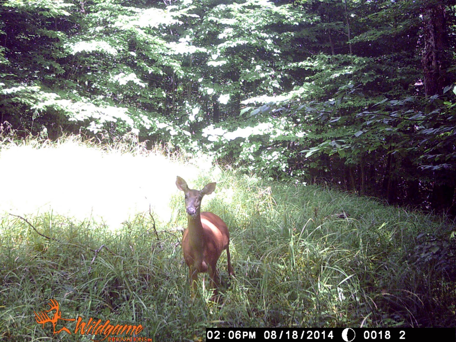
the latter never). Secondly, it showed how many deer and their size. In this
case, a nice sized doe with a fawn.
I know. I know. Much of this can be discerned from reading
the sign. And yes, I could tell it was a doe and her fawn from the tracks. And
if I was good enough, I could have reached some reasonable estimate on how
frequently they were visiting the area. I’m not to that level yet, and even if
I was, it would still be good fun to set the cameras.
However, there is one
thing that makes me very uncomfortable: a couple pictures show the doe looking
alarmingly at the camera. I’ve always felt that maintaining an element of surprise is biggest advantage a hunter
has over big game. These deer are nearly three miles in a
wilderness area. It is rarely hiked and probably never hunted. Essentially, they are unpressured deer. That’s a huge advantage for us, and I fear we may
have lost it. There’s likely enough time before the start of the season (Oct. 1st)
for things to calm down and return to normal. But I have an uneasy feeling that
won’t go away. The kind you get when you see the tail end of a deer you just spooked. I'm also eager to set another camera.
Friday, August 22, 2014
Blogging Again . . . In the Catskills
Well, I have decided to start blogging again. Who knows how long it will last. Since my last post, I have graduated from college, found a job, and moved to a new region. I believe it was 2008 when I took up hunting again. That was in Washington, a place I had never hunted before, pursuing an animal I had never hunted before with a weapon I had never hunted with before. It was a steep learning curve, to say the least, but I justified the time and energy and expense with the belief that the rewards (meat in the freezer) would eventually come once I gained enough familiarity with the area and the quarry. Then after two years, just when I was starting to gain some confidence--I moved, all the way to New York.
This time the learning curve was not as steep. I had hunted whitetail before and was familiar with the tactics for doing so. Plus, I could use my gun. Still, I invested considerable time scouting the new area to learn its ins and outs. Over the course of three years, I switched between hunting public land, to participating in the various components of the Cornell Deer Hunting Program, to hunting private land, and then a combination of all three. In short, I never really got my bearings with the land and the habits of the deer, though I did manage to take a couple deer. Had I stayed, this would have been the year that I felt comfortable with the area and I would have been able to script a pretty solid game plan. Then I got a job.
Now I'm in a new region: the Catskills of New York. And so, I start the cycle all over again. It's a process I truly enjoy, but it is also very time consuming. And if history is any indication, it doesn't bode well for filling the freezer. I have always regretted not blogging about my experience of learning how to elk hunt. There were so many fresh thoughts and experiences and insights that have now slip my mind. It is a bit of a pity. And so, not wanting to make the same mistake twice, I figure I'll document my experience of learning to hunt the Catskills.
I have no justification for including the picture below. Just that I almost stepped on the fellow while scouting, and I'm not quite sure what to make of sharing the woods with this new predator. At the very least, can't have a blog post without a picture, right?
Sunday, June 30, 2013
Mushrooms
It's been raining for the past couple weeks and that can only mean one thing: mushrooms.
I generally do most of my foraging at the Finger Lake National Forest. There's no particular justification for this preference; it just happened that when I first moved here the FLNF is where I went and now it has become somewhat of habit. I've done alright there with fruits and berries, but the mushroom harvest--save some Chicken-of-the-Woods and Oysters--as been lackluster at best.
So I decided to explore some more options. Yesterday I headed up to Yellow Barn State Forest. It has one snowmobile trail through it but lacks hiking and mountain bike trails, which I always view as a positive.
I took Maizie, who was asleep for most it, so I couldn't cover a lot of ground (she refuses to ride in any type of backpack so I have to carry her). Its got a good mix of Oaks and Hemlock, a stream or two, and some open field areas. And for what its worth, its got a nice feel to it as well.
Sometimes I have a tendency to walk to fast in hopes of covering more ground. The thought is to walk fast until I see some mushrooms and then slow down and search the area more thoroughly. It almost never works; I usually just walk right past them. Good thing, then, that I have Maizie to slow me down. I always find good stuff with her for this reason. She forces me to stop and then I begin to notice some type of foot laying just underfoot.
Yesterday was no different. I found some boletes while stopping to give her some water and what I thought was my first cauliflower mushroom (Yay!), but it turns out is something else I can't id. In fact, my "All That the Rain Offers" book is missing some I can't even id the boletes.

What I thought was a Cauliflower. Oh the joy! And the subsequent disappointment!

It was almost too cute to harvest. I believe these are the "choice" boletes. They sure smell choice!


Easy to see why I likely walk right by so many mushrooms. It took me five minutes of sitting in the same area before I was able to see this mushroom about five yards away.

Don't know what this is but it looks scary so I left it alone. Curiosity kills the mushroom forager.

Maze after waking up from her nap and finding herself in a forest. Must be a cool experience.
Subscribe to:
Posts (Atom)